Enfield Secondary Planning Strategy

Enfield Secondary Planning Strategy
The Municipality is experiencing high levels of growth and in recent years several large parcels of land in South Corridor (Enfield, Elmsdale and Lantz) have been approved for development. Development and growth has been occurring at a rate not experience in the municipality before. We are now facing a limited supply of land with municipal water and wastewater services available.
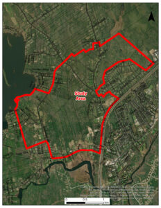
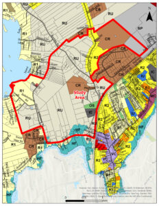
The Municipality has hired Fathom Studio to complete a Secondary Planning Strategy for approximately 565 hectares of land in Enfield. The Secondary Planning Strategy will study an area of land in Enfield between Grand Lake and Highway 102. Much of this land has been identified for future development growth for several years.
The final Secondary Planning Strategy will include a plan for the area which will lead to a better design for the community and help the municipality consider what infrastructure is needed for the land to be developed in the future.
When developing the vision and plan for the future development of the land, we will be asking the community for feedback, including landowners in the study area and local residents.
Community Engagement Workshop
Thursday | November 5, 2026
7:00 p.m. – 8:30 p.m.
Royal Canadian Legion Branch 133, 50 Old Enfield Road, Enfield
Join us to share your ideas and priorities
for the future of the Grand Lake / Horne
Settlement area of Enfield!
Take the Public Survey
If you are unable to attend the workshop, a public survey will be open from October 27 to November 9, 2026.
Frequently Asked Questions
A secondary plan contains policies and zoning regulations in an area of the Municipality where major changes are expected and desired.
The Secondary Planning Strategy will include a high-level review of what infrastructure is needed to provide the area with piped municipal water and wastewater services. How the land will connect to existing roads will also be investigated.
The Secondary Planning Strategy will look at the need and location for different land uses which will include housing with a variety of density, commercial, community and mixed-uses.
The study may identify constraints which need to be investigated prior to any development approval. The servicing of the land with municipal piped water and wastewater services will need to be fully investigated. The land is also in private ownership by several landowners and the timelines for development will be dependant on these landowners desire to develop and timelines.
Here is the map of the study area:
Project Status
Active
Contact Us
If you have questions about this project, please reach out to:
Rachel Gilbert
Manager of Planning
902-883-6122
[email protected]
Documents
Phase 1 Report
A review of the study area’s development potential.
Timeline
Project Start Date
Spring 2026
Fathom Studio were selected as the consultants for the project.
Phase 1 Study Completed
July 2026
The Phase 1 Study is a high-level review of the development potential of the area.
Collect Public Feedback
October/November 2026
Public and landowner feedback will be sought with an in-person event and online survey.
Concept Plan Development
Fall 2026
This will include a second in-person event with the community.
Completion of Concept Plan
February 2026
Fathom Studio will complete the project and hand over the recommendations and concept plan to the Municipality.
Note: The timeline steps may be amended and further steps may be added through the course of the project.